
Glenns guidebok for Sannäs
Coast and Scenic places
Visiting the Koster Islands is like taking a holiday from everyday life, only a short boat trip (regular ferrys) from Strömstad. Once you arrive, you are greeted by an amazing archipelago, picturesque fishing villages in a gloriously beautiful natural landscape, breath-taking views and much more.
Kosteroarna
Visiting the Koster Islands is like taking a holiday from everyday life, only a short boat trip (regular ferrys) from Strömstad. Once you arrive, you are greeted by an amazing archipelago, picturesque fishing villages in a gloriously beautiful natural landscape, breath-taking views and much more.
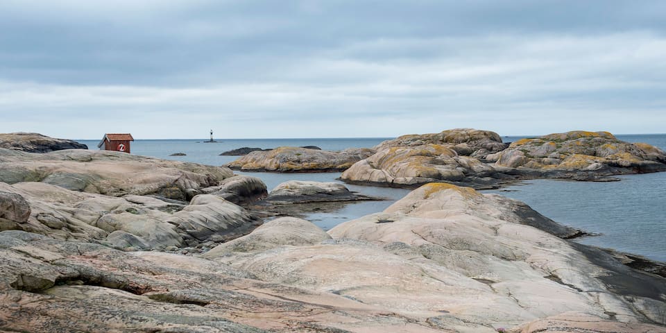
One of the most wild an unprotected areas along the Swedish north west coast. Granite rocks, salt water waves and a lighthouse that can be seen outside the bay. A short walk about 5 km but you easily spend 2-3 hours here and remember to bring the coffee basket as there’s no commercial activity. It is located 15-20 minutes by car from Sannäs and is astonishing in all weathers, just bring the right clothes.
We recommend to finish the walk with a bite of food at “Bistro Tjurpannan”. Check out the opening hours at their website.
39 Recomendado por los habitantes de la zona
Tjurpannans Nature Preserve
22 LÅNGEBYOne of the most wild an unprotected areas along the Swedish north west coast. Granite rocks, salt water waves and a lighthouse that can be seen outside the bay. A short walk about 5 km but you easily spend 2-3 hours here and remember to bring the coffee basket as there’s no commercial activity. It is located 15-20 minutes by car from Sannäs and is astonishing in all weathers, just bring the right clothes.
We recommend to finish the walk with a bite of food at “Bistro Tjurpannan”. Check out the opening hours at their website.
Walk for 3 km around the beautiful nature reserve Veddö, just north of Fjällbacka, with the ocean by your side throughout most of the walk.
Start by the fence next to the pen and walk to the first gate on the right hand side. Walk through the gate and follow the path straight ahead. If you are lucky you get to see the friendly sheep along the way. The trail starts once you reach the boathouse on the left hand side. On rainy days the cliffs become very slippery so make sure you are careful! On your way up the hill you will see the silhouette of Fjällbacka on your left, and once you are on the top of the mountain you will see the entire Fjällbacka archipelago with the Weather Islands far west. From here you can also see Veddös south cape with two Bronze Age cairns, which you can visit if you want to make a small detour. These were used during the Bronze Age as temporary accommodation when the locals were out fishing or hunting.
From here, there is a relatively steep path down to the lowland of the nature reserve, where the trail turns northwest and follows the waterside along Musöfjorden. The trail goes through meadows with grazing animals that walk around freely during the summer to make sure the ground doesn't overgrow, in order to preserve the cultural landscape that is known to the Bohuslän archipelago. You can meet both cows and horses that are not dangerous as long as you don't bother them. After the gate, the trail crosses over two wooden bridges along the edge of the cliff and on the second bridge there is a bench that you can sit on to relax and enjoy the surroundings.
After the bridges, there is a small meadow just as you pass Veddöhals. This is a great place to go into the water as there are two lovely sandy beaches on each side of the cliffs. After Veddöhals you will follow the path uphill over some big rocks. Make sure you are careful, as some rocks are not situated well. On the top of the hill the view is magnificent and if you turn and look south you will see large parts of the inner archipelago and the Weather Islands. If you look north you will see some of the lights from Grebbestad and the wind power stations in the hinterland. The path wiggles its way down to Skutebacksbukten, which has a lovely and spacious beach. It also has outdoor toilets, which are open in the summertime. Above the beach, there are many plants and mushrooms growing, such as different waxcaps, Early purple orchids, Cat's-foot flowers, and moonwort.
Go through the steel gate and follow the dirt road to get back to the parking lot.
Directions and tips
The trail is ranked as medium in difficulty. It consists mostly of proper paths but in some places it has rocks and steep hills. On rainy days there is a great risk of slipping on the cliffs. Remember that it is a nature reserve and that certain rules must be obeyed. Always close the gates after you go through them, be respectful to the grazing animals and do not litter.
Drive on road 163. When you get 3 km north of Fjällbacka, turn towards Veddö and drive along Veddövägen until you reach the lower parking lot.
17 Recomendado por los habitantes de la zona
Veddö Nature reserve
21 VeddövägenWalk for 3 km around the beautiful nature reserve Veddö, just north of Fjällbacka, with the ocean by your side throughout most of the walk.
Start by the fence next to the pen and walk to the first gate on the right hand side. Walk through the gate and follow the path straight ahead. If you are lucky you get to see the friendly sheep along the way. The trail starts once you reach the boathouse on the left hand side. On rainy days the cliffs become very slippery so make sure you are careful! On your way up the hill you will see the silhouette of Fjällbacka on your left, and once you are on the top of the mountain you will see the entire Fjällbacka archipelago with the Weather Islands far west. From here you can also see Veddös south cape with two Bronze Age cairns, which you can visit if you want to make a small detour. These were used during the Bronze Age as temporary accommodation when the locals were out fishing or hunting.
From here, there is a relatively steep path down to the lowland of the nature reserve, where the trail turns northwest and follows the waterside along Musöfjorden. The trail goes through meadows with grazing animals that walk around freely during the summer to make sure the ground doesn't overgrow, in order to preserve the cultural landscape that is known to the Bohuslän archipelago. You can meet both cows and horses that are not dangerous as long as you don't bother them. After the gate, the trail crosses over two wooden bridges along the edge of the cliff and on the second bridge there is a bench that you can sit on to relax and enjoy the surroundings.
After the bridges, there is a small meadow just as you pass Veddöhals. This is a great place to go into the water as there are two lovely sandy beaches on each side of the cliffs. After Veddöhals you will follow the path uphill over some big rocks. Make sure you are careful, as some rocks are not situated well. On the top of the hill the view is magnificent and if you turn and look south you will see large parts of the inner archipelago and the Weather Islands. If you look north you will see some of the lights from Grebbestad and the wind power stations in the hinterland. The path wiggles its way down to Skutebacksbukten, which has a lovely and spacious beach. It also has outdoor toilets, which are open in the summertime. Above the beach, there are many plants and mushrooms growing, such as different waxcaps, Early purple orchids, Cat's-foot flowers, and moonwort.
Go through the steel gate and follow the dirt road to get back to the parking lot.
Directions and tips
The trail is ranked as medium in difficulty. It consists mostly of proper paths but in some places it has rocks and steep hills. On rainy days there is a great risk of slipping on the cliffs. Remember that it is a nature reserve and that certain rules must be obeyed. Always close the gates after you go through them, be respectful to the grazing animals and do not litter.
Drive on road 163. When you get 3 km north of Fjällbacka, turn towards Veddö and drive along Veddövägen until you reach the lower parking lot.
Fjällbacka is a very nice small fishing village that is a hotspot for summer tourists. While you are there, you must go to Kungsklyftan just next to the “high street” and then also walk all the stairs to a magnificent view point overlooking the harbour and archipelago. In Fjällbacka the once famous actress Ingrid Bergman had a summer house with her late husband Lasse Schmidt on island Dannholmen just outside Fjällbacka. There is a statue of Ingrid in the harbour of Fjällbacka. It is also the town where famous noir writer, Camilla Läckberg, grew up.
14 Recomendado por los habitantes de la zona
Kungsklyftan Fjällbacka
Fjällbacka is a very nice small fishing village that is a hotspot for summer tourists. While you are there, you must go to Kungsklyftan just next to the “high street” and then also walk all the stairs to a magnificent view point overlooking the harbour and archipelago. In Fjällbacka the once famous actress Ingrid Bergman had a summer house with her late husband Lasse Schmidt on island Dannholmen just outside Fjällbacka. There is a statue of Ingrid in the harbour of Fjällbacka. It is also the town where famous noir writer, Camilla Läckberg, grew up.
Väderöarna (“The Weather Islands”) are a group of islands in the west archipelago in Sweden off Fjällbacka, in Bohuslän. It is a nature reserve where you can hike, swim, watch seals and sea-birds and enjoy really fresh seafood. You get here by the private ferries operated by the "Väderöarna Inn", typically from Fjällbacka or Hamburgsund. Check out their website.
Väderöarna have one of Sweden's warmest but also windiest climates, which clearly influences the flora and fauna on the islands. In the summer you can book a boat trip to one of Bohuslän's largest seal colonies here. There is also a rich diversity of bird species, with good chances of spotting skua, shags andblack guillemots. Fascinating diving adventures await you in one of Sweden's two living coral reefs off the islands. Väderöarna are considered to be one of the country's most valuable marine areas and were classified as a nature reserve in 2012.
27 Recomendado por los habitantes de la zona
Väderöarnas Värdshus
1a FärjelägetVäderöarna (“The Weather Islands”) are a group of islands in the west archipelago in Sweden off Fjällbacka, in Bohuslän. It is a nature reserve where you can hike, swim, watch seals and sea-birds and enjoy really fresh seafood. You get here by the private ferries operated by the "Väderöarna Inn", typically from Fjällbacka or Hamburgsund. Check out their website.
Väderöarna have one of Sweden's warmest but also windiest climates, which clearly influences the flora and fauna on the islands. In the summer you can book a boat trip to one of Bohuslän's largest seal colonies here. There is also a rich diversity of bird species, with good chances of spotting skua, shags andblack guillemots. Fascinating diving adventures await you in one of Sweden's two living coral reefs off the islands. Väderöarna are considered to be one of the country's most valuable marine areas and were classified as a nature reserve in 2012.
A small fishing village with a narrow passage that most boats pass by in protected waters. There is a shell fish bistro and marine grocer start.
8 Recomendado por los habitantes de la zona
Havstenssund
A small fishing village with a narrow passage that most boats pass by in protected waters. There is a shell fish bistro and marine grocer start.
Local spots
Things to do in the Sannäs area.
Sannäs
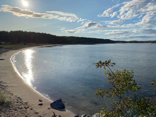
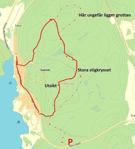
A nice 5 km trail with forest and rocks and viewpoints, just around the corner.
A nice walking or running trail 5 km starting from Villa Sannäs. Forest, view over Sannäs Fjord and across the golf course.
Sannäsfjorden
A nice walking or running trail 5 km starting from Villa Sannäs. Forest, view over Sannäs Fjord and across the golf course.
Matkultur
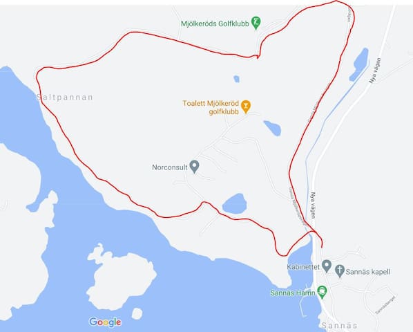
A beautiful goolf course inSannäs with a nice club house that boasts a restaurant and bar.
8 Recomendado por los habitantes de la zona
Mjölkeröds Golfklubb
22 MJÖLKERÖDA beautiful goolf course inSannäs with a nice club house that boasts a restaurant and bar.
Local restaurant 15 mins away with car. Only open during seasons. Check out their facebook page.
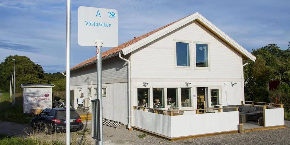
Restaurang Cafe Västbacken
1 VästbackenLocal restaurant 15 mins away with car. Only open during seasons. Check out their facebook page.
Nice seafood restaurant in Grebbestad, 15 mins by car south of Sannäs. Check their web site for opening hours.
13 Recomendado por los habitantes de la zona
Grebys Hotell & Restaurang
1 StrandvägenNice seafood restaurant in Grebbestad, 15 mins by car south of Sannäs. Check their web site for opening hours.
Local good bistro restaurant in Grebbestad 15 mins by car south from Sannäs.
10 Recomendado por los habitantes de la zona
Restaurant Telegrafen
28 Nedre LånggatanLocal good bistro restaurant in Grebbestad 15 mins by car south from Sannäs.
Great bakery and café with a good selection of bread and pastries. Their brekafast buffet is recommended. A bargain for a really good breakfast.
17 Recomendado por los habitantes de la zona
Sjögrens i backen
34 Nedre LånggatanGreat bakery and café with a good selection of bread and pastries. Their brekafast buffet is recommended. A bargain for a really good breakfast.
Sports and activities
Kayak to rent or join organised tours.
Read more on their website: https://www.nautopp.com/?lang=en
Kajakcenter
SvinnäsvägenKayak to rent or join organised tours.
Read more on their website: https://www.nautopp.com/?lang=en
A wonderful day paddle trip starting in Grönemad, Grebbestad.
Start your day at the kayakcentre Skärgårdsidyllen Kayak & Outdoor and paddle ahead the islands Gåsöarna. Look up at the steep cliff walls between North Gåsö and Gåsöhumpen where some adrenaline junkees jump of the 10-14 meter high cliffs to swim in the ocean. Then, depending on the weather conditions and the level of experience, choose to paddle inshore or outshore proceeding after Gåsöklippan (the Gåsö cliff).
If you choose to paddle inshore, you will paddle between Big Kännskär and Big Gåsö, and take sight on Solust and the shell beach at the north east side of Pinnö. The passage between South Gåsö and Solust can be a bit rough as the sea opens and no sheltering rocks. At the inshore side of Solust you will find an outdoor toilet. Enjoy some food at the beach or take a swim in the beautiful clear water. Bring your goggles and snorkel! Don't pick the oysters as they belong to the landowner. If you want to taste or learn more about oysters we recommend you to book a guided tour with Skärgårdsidyllen Kayak & Outdoor, or Bröderna Klemming.
From here you can either turn back to Grönemad, or continue to paddle around the island Otterön before you head back. They route back to Grönemad from Pinnö is inshore and follows the coastline where you can enjoy the view of genuine fisherman huts, fishingboats and the daily life of the small fishing village at shore.
If you want to make a longer trip, you can continue paddling south of Pinnö ahead Otterön. If you're lucky you can spot seals at Testholmarna. Paddle close to the cliffs to stay away from fast going boats, and to get closer to the wildlife but without interfering with the animals.
When the weather conditions are good, experienced paddlers can take sight on Big Måkholmen to have lunch here. The rout goes by the lighthouse at Otterön, followed by the sound of Klövudden (where there is a outdoor toilet), and then continues to Big Måkholmen. You will find a beautiful beach at the east side of Big Måkholmen where you easily can reach the shore and pull up your kayak. A good reminder is to bring your equipment from your kayak, and pull the kayak a few meters from the beach to make it accessible for swimmers.
At Måkholmen you will enjoy a fantastic view of the horizon and the most beautiful sunset. In south east direction you can see all the way to the famous Weather Islands. In the middle of the island you will find an old labyrinth made of stone. This island is a very popular overnight stay. Just have in mind that the weather conditions easily can change, and that you are more exposed for strong winds and waves when you are outshore. Take a stroll over the cliffs to explore this wonderful island and its birdlife.
Leaving Big Måkholmen you will head east between Otterön and Musön. Looking at Musön you will see the big rocks torn up against the sky, and discover a big amount of stone formations that people put there like artwork. They are not to be mistaken by the old Norse stone formations or relics as you can see at Otterön. If you keep south in the sound you can turn in through Musö-sältan and continue by the south side at Björnåsen. You will find popular overnight places at the north east side of Musö, and at Small and Big Brattholmen. The project Hållbar Skärgård (Sustainable Archipelago) will establish solar powered toilets here.
Now you are inshore and close to the coastline of the mainland. Take the chance to get ashore at TanumStrand or Grebbestad and stroll the bridge of Grebbestad to explore the pulse, have an icecream or discover the many restaurants and shops. Then you can continue in north westly direction between the ligthouses at Svinnäs on your way back to Grönemad. You can paddle close to the coastline inshore at Lökholmen, Porsholmen, Bastholmen before returning to the beach in Grönemad where you started your trip.
Grönemads Hamnförening
6 Lambs vägA wonderful day paddle trip starting in Grönemad, Grebbestad.
Start your day at the kayakcentre Skärgårdsidyllen Kayak & Outdoor and paddle ahead the islands Gåsöarna. Look up at the steep cliff walls between North Gåsö and Gåsöhumpen where some adrenaline junkees jump of the 10-14 meter high cliffs to swim in the ocean. Then, depending on the weather conditions and the level of experience, choose to paddle inshore or outshore proceeding after Gåsöklippan (the Gåsö cliff).
If you choose to paddle inshore, you will paddle between Big Kännskär and Big Gåsö, and take sight on Solust and the shell beach at the north east side of Pinnö. The passage between South Gåsö and Solust can be a bit rough as the sea opens and no sheltering rocks. At the inshore side of Solust you will find an outdoor toilet. Enjoy some food at the beach or take a swim in the beautiful clear water. Bring your goggles and snorkel! Don't pick the oysters as they belong to the landowner. If you want to taste or learn more about oysters we recommend you to book a guided tour with Skärgårdsidyllen Kayak & Outdoor, or Bröderna Klemming.
From here you can either turn back to Grönemad, or continue to paddle around the island Otterön before you head back. They route back to Grönemad from Pinnö is inshore and follows the coastline where you can enjoy the view of genuine fisherman huts, fishingboats and the daily life of the small fishing village at shore.
If you want to make a longer trip, you can continue paddling south of Pinnö ahead Otterön. If you're lucky you can spot seals at Testholmarna. Paddle close to the cliffs to stay away from fast going boats, and to get closer to the wildlife but without interfering with the animals.
When the weather conditions are good, experienced paddlers can take sight on Big Måkholmen to have lunch here. The rout goes by the lighthouse at Otterön, followed by the sound of Klövudden (where there is a outdoor toilet), and then continues to Big Måkholmen. You will find a beautiful beach at the east side of Big Måkholmen where you easily can reach the shore and pull up your kayak. A good reminder is to bring your equipment from your kayak, and pull the kayak a few meters from the beach to make it accessible for swimmers.
At Måkholmen you will enjoy a fantastic view of the horizon and the most beautiful sunset. In south east direction you can see all the way to the famous Weather Islands. In the middle of the island you will find an old labyrinth made of stone. This island is a very popular overnight stay. Just have in mind that the weather conditions easily can change, and that you are more exposed for strong winds and waves when you are outshore. Take a stroll over the cliffs to explore this wonderful island and its birdlife.
Leaving Big Måkholmen you will head east between Otterön and Musön. Looking at Musön you will see the big rocks torn up against the sky, and discover a big amount of stone formations that people put there like artwork. They are not to be mistaken by the old Norse stone formations or relics as you can see at Otterön. If you keep south in the sound you can turn in through Musö-sältan and continue by the south side at Björnåsen. You will find popular overnight places at the north east side of Musö, and at Small and Big Brattholmen. The project Hållbar Skärgård (Sustainable Archipelago) will establish solar powered toilets here.
Now you are inshore and close to the coastline of the mainland. Take the chance to get ashore at TanumStrand or Grebbestad and stroll the bridge of Grebbestad to explore the pulse, have an icecream or discover the many restaurants and shops. Then you can continue in north westly direction between the ligthouses at Svinnäs on your way back to Grönemad. You can paddle close to the coastline inshore at Lökholmen, Porsholmen, Bastholmen before returning to the beach in Grönemad where you started your trip.
Forest trail to Dragonkullen - a borderline hike to the top that rises 170 m.ö.h. The lookout tower rises another 10m, just above the treetops, which means that you have a clear view all around the horizon and offers a fantastic view of the Svinesund bridges, the Idefjord and far into Norway. In clear weather, you can see the 1883 meter high Gaustatoppen at Rjukan in Telemark, Norway, lying covered in snow with its "Fujijama profile".
The very name of the Dragon Hill descent probably comes from dragons (infantrymen) from Charles XII's army who were stationed or scouted from there during the years of unrest 1715-1718 in these areas.
Read more here: https://www.vastsverige.com/stromstad/produkter/utsiktsplatser/
Dragonkullen
Forest trail to Dragonkullen - a borderline hike to the top that rises 170 m.ö.h. The lookout tower rises another 10m, just above the treetops, which means that you have a clear view all around the horizon and offers a fantastic view of the Svinesund bridges, the Idefjord and far into Norway. In clear weather, you can see the 1883 meter high Gaustatoppen at Rjukan in Telemark, Norway, lying covered in snow with its "Fujijama profile".
The very name of the Dragon Hill descent probably comes from dragons (infantrymen) from Charles XII's army who were stationed or scouted from there during the years of unrest 1715-1718 in these areas.
Read more here: https://www.vastsverige.com/stromstad/produkter/utsiktsplatser/
Take a day trip 40 mins by car from Sannäs and watch endangered animals in the popular animal park You can meet as many as 80 of the world's endangered species at Nordens Ark. At Lantgården you can get up close to Nordic country breeds and the children can jump in hay and milk cows. The animal park is one of rural Bohuslän’s most popular tourist destinations with its beautiful countryside and the opportunity of seeing animals such as the wolf, the snow leopard and the Amur tiger. The park is open every day, the whole year round.
88 Recomendado por los habitantes de la zona
Nordic Ark
Åby säteriTake a day trip 40 mins by car from Sannäs and watch endangered animals in the popular animal park You can meet as many as 80 of the world's endangered species at Nordens Ark. At Lantgården you can get up close to Nordic country breeds and the children can jump in hay and milk cows. The animal park is one of rural Bohuslän’s most popular tourist destinations with its beautiful countryside and the opportunity of seeing animals such as the wolf, the snow leopard and the Amur tiger. The park is open every day, the whole year round.
A tour just under one hour by car from Sannäs and get close to the sea and meet hundreds of fascinating species. Live life in Västerhavet for a while, and get close up to hundreds of fascinating marine species from the lesser-spotted dogfish to the long spined sea-scorpion. With around 40 aquariums and other exciting activities like seal safaris and beach schools, no wonder Havets Hus is one of the most popular destinations in Bohuslän!
Hundreds of different species
Havets Hus is a salt-water aquarium that displays hundreds of different species from Gullmarsfjorden and Västerhavet. The aquarium has many exciting things to offer and your journey begins in the shallows by the beach, continuing through Västerhavet’s different environments, all the way down to the deep dark depths.
In the tunnel aquarium you walk in dry shoes surrounded by water, among thornback ray, cod and conger eels. In Blågyltan assembly hall you’ll be captivated by the marine life behind the huge sheet of acrylic glass as you sit in front of the cylindrical aquarium. The hall is turned into a film theatre several times a day.
58 Recomendado por los habitantes de la zona
Havets Hus i Lysekil
9 StrandvägenA tour just under one hour by car from Sannäs and get close to the sea and meet hundreds of fascinating species. Live life in Västerhavet for a while, and get close up to hundreds of fascinating marine species from the lesser-spotted dogfish to the long spined sea-scorpion. With around 40 aquariums and other exciting activities like seal safaris and beach schools, no wonder Havets Hus is one of the most popular destinations in Bohuslän!
Hundreds of different species
Havets Hus is a salt-water aquarium that displays hundreds of different species from Gullmarsfjorden and Västerhavet. The aquarium has many exciting things to offer and your journey begins in the shallows by the beach, continuing through Västerhavet’s different environments, all the way down to the deep dark depths.
In the tunnel aquarium you walk in dry shoes surrounded by water, among thornback ray, cod and conger eels. In Blågyltan assembly hall you’ll be captivated by the marine life behind the huge sheet of acrylic glass as you sit in front of the cylindrical aquarium. The hall is turned into a film theatre several times a day.
At this resort you can rent small motor boats for day trips. Have a look here:
https://www.tanumstrand.se/aktivitet/batar/
Next by Tanum Strand you also find Sportshopen one of the largest sport clothes outlet in the Nordic area.
16 Recomendado por los habitantes de la zona
TanumStrand
At this resort you can rent small motor boats for day trips. Have a look here:
https://www.tanumstrand.se/aktivitet/batar/
Next by Tanum Strand you also find Sportshopen one of the largest sport clothes outlet in the Nordic area.
Sightseeing
The Greby Burial Ground is the largest in Bohuslän. There are more than 180 visible graves, but the true number is probably much higher.
The Greby Burial Ground is the largest in Bohuslän. There are more than 180 visible graves, but the true number is probably much higher. Legend has it that Scots warriors are buried in the mounds. Eleven of the graves were excavated in 1873 by Oscar Montelius, a well known archeology and prominent figure in Swedish archeology. The graves contained no weapons, only personal artifacts. The dead had been cremated, and the burnt bones put into clay pots. Dating of the excavated graves put them from the Iron Age, from 400-500 A.D.
At the time when the graves were established, there was a shallow bay just to the west, a bay that was an extension of Sannäs Fjord with connections to the open sea at Havstensund and at Edsvik. Using Edsvik as the entry point, it was possible to avoid the dangerous waters at Tjurpannan. The entry at Edsvik was guarded by a fortress that still exists today.
The large number of graves here at Greby and at Gissleröd, nearby are indication that this area was of special significance in the centuries after the birth of Christ. The finds from the excavations in 1873 point to connections with Norway, England and Germany. Greby was posibly a trading place associated with a large farm where goods and products from this part of northern Bohuslän were bartered for goods from other areas.
We do not know when or how it lost its significance. Possibly it was due to the bay silting up and becoming to shallow to sail in, or that the site was attacked and plundered. In which case there could be some truth in the legend about the Scots.
Greby
10 GREBYThe Greby Burial Ground is the largest in Bohuslän. There are more than 180 visible graves, but the true number is probably much higher.
The Greby Burial Ground is the largest in Bohuslän. There are more than 180 visible graves, but the true number is probably much higher. Legend has it that Scots warriors are buried in the mounds. Eleven of the graves were excavated in 1873 by Oscar Montelius, a well known archeology and prominent figure in Swedish archeology. The graves contained no weapons, only personal artifacts. The dead had been cremated, and the burnt bones put into clay pots. Dating of the excavated graves put them from the Iron Age, from 400-500 A.D.
At the time when the graves were established, there was a shallow bay just to the west, a bay that was an extension of Sannäs Fjord with connections to the open sea at Havstensund and at Edsvik. Using Edsvik as the entry point, it was possible to avoid the dangerous waters at Tjurpannan. The entry at Edsvik was guarded by a fortress that still exists today.
The large number of graves here at Greby and at Gissleröd, nearby are indication that this area was of special significance in the centuries after the birth of Christ. The finds from the excavations in 1873 point to connections with Norway, England and Germany. Greby was posibly a trading place associated with a large farm where goods and products from this part of northern Bohuslän were bartered for goods from other areas.
We do not know when or how it lost its significance. Possibly it was due to the bay silting up and becoming to shallow to sail in, or that the site was attacked and plundered. In which case there could be some truth in the legend about the Scots.
A historic site with rock carvings from the Bronze Age. Paths outdoor as well as a nice indoor museum. Fun things also for kids. Located about 20 mins by car from Villa Sannäs.
Vitlycke museum gives you a real insight into the Bronze Age world and is a great experience for the whole family. You’ll be fascinated by the landscape and the well-preserved rock carvings, which are on the Unesco World Heritage List.
47 Recomendado por los habitantes de la zona
Vitlycke Museum
2 VitlyckeA historic site with rock carvings from the Bronze Age. Paths outdoor as well as a nice indoor museum. Fun things also for kids. Located about 20 mins by car from Villa Sannäs.
Vitlycke museum gives you a real insight into the Bronze Age world and is a great experience for the whole family. You’ll be fascinated by the landscape and the well-preserved rock carvings, which are on the Unesco World Heritage List.
Tanum’s Rock Art Research Centre is a non-commercial institution run by Scandinavian Society for Prehistoric Art.
- The exhibition offers a good introduction to the images/icons of the past with exemples from Scandinavia and the rest of the world.
- Visit the library.
- We offer guided excursions by day and by night: rock carvings are best seen in artificial light.
The museum:
- Centre of Documentation and registration of rock art endangered by the environmental pollution.
- holds the World Heritage Archive.
- Is the only institution in North Europe that offers courses on the documentation of rockcarvings.
- organises annual international workseminars
- Publications: The annual magazine "Adoranten" and series Documentation and "Registration of Rock Art in Tanum".
Please contact the museum for bookings.
Tanums Hällristningsmuseum UNDERSLÖS
UnderslösTanum’s Rock Art Research Centre is a non-commercial institution run by Scandinavian Society for Prehistoric Art.
- The exhibition offers a good introduction to the images/icons of the past with exemples from Scandinavia and the rest of the world.
- Visit the library.
- We offer guided excursions by day and by night: rock carvings are best seen in artificial light.
The museum:
- Centre of Documentation and registration of rock art endangered by the environmental pollution.
- holds the World Heritage Archive.
- Is the only institution in North Europe that offers courses on the documentation of rockcarvings.
- organises annual international workseminars
- Publications: The annual magazine "Adoranten" and series Documentation and "Registration of Rock Art in Tanum".
Please contact the museum for bookings.
Handcraft & Art
Local handcraft and art
A well established and pretty large pottery combined with art gallery, located close to E6 some 15-20 mins by car south of Sannäs. Tricky to find the exit, but follow signs or your navigation device.
Solhem Krukmakeri
10 SOLHEMA well established and pretty large pottery combined with art gallery, located close to E6 some 15-20 mins by car south of Sannäs. Tricky to find the exit, but follow signs or your navigation device.
Shopping
Nordics largest sport clothes outlet.
Sportshopen