
- Sveti Juraj area guide -
Sveti Juraj & Senj
SENJ,
10 km from Sveti Juraj.
Senj is located where the mountain’s edge is washed by the sea, where intact nature, clean air and crystal clear waters invigorate the body, and where history and culture foster renewal of the spirit. It’s a town renowned for its eventful history, cutural heritage, literature and tradition. Senj is the centre of a region covering more than 650 km2 and encompassing numerous small towns and villages dotted along the shore at the foot of Mount Velebit (Sv. Juraj, Lukovo, Klada, Starigrad, Jablanac, Stinica and Prizna) or higher up in the mountains of Velebit and Kpela (Krasno, Krivi Put, Stolac, Vratnik and Senjska Draga). The region’s areas of natural heritage preservation are the Velebit Nature Park and Croatia’s youngest national park – Northern Velebit.
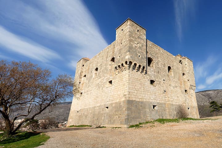
The moment you arrive in Senj, you encounter remnants on all sides of its brave, proud history dating back more than three millennia. The most monumental fortress in the entire Croatian Littoral, the Nehaj fortress, was built in 1558 to defend the town from Turk and Venetian attacks. The extraordinarily rich history of Senj was recorded by the hand of many noted local writers, therefore we are confident that you will always find a new reason to revisit this town and to make your way anew down its narrow, winding streets, breathing in air refreshed by the famous bura wind.
Numerous events, based on local traditions and culture, are always quite a special experience for any visitor. The people of Senj have always loved Carnival – both in winter and, quite uniquely, in summer, because each August Senj hosts an international carnival. Carnival always means loads of fun, so it is no wonder that the whole of the town lives for this time of the year. On the more spiritual side, a pilgrimage to the sanctuary of Our Lady of Krasno will restore your sense of inner peace, while stories about the red-haired Zora and her gang can make us feel like children once again. The festival of klape singing groups, musical evenings in the cathedral, days of uskoks, samba festival, fishermen’s festivals, folklore, concerts and many other events will remain in the memory of visitors, inviting them to visit this town once again.
Senj and its surroundings offer various possibilities to those interested in sports and other action-packed holidays. The sea is a constant challenge: dive into its blue depths, experience the beauty of undersea gardens, set sail in favourable winds, try your luck at fishing, or just relax on a sunny beach and take in the healthy maritime air. The mountains also offer plenty of possibilities for recreation and adventure, numerous hiking trails with wonderful views of the surrounding areas, diverse biking trails, free climbing, hunting, caving or snow sports in winter. But do not miss the unique opportunity to swim in the sea in the morning and then enjoy the shaded mountain landscapes in the afternoon!
There is a lot of historical places to visit in Senj:
https://visitsenj.com/en/senj-riviera/senj/
77 Recomendado por los habitantes de la zona
Senj
SENJ,
10 km from Sveti Juraj.
Senj is located where the mountain’s edge is washed by the sea, where intact nature, clean air and crystal clear waters invigorate the body, and where history and culture foster renewal of the spirit. It’s a town renowned for its eventful history, cutural heritage, literature and tradition. Senj is the centre of a region covering more than 650 km2 and encompassing numerous small towns and villages dotted along the shore at the foot of Mount Velebit (Sv. Juraj, Lukovo, Klada, Starigrad, Jablanac, Stinica and Prizna) or higher up in the mountains of Velebit and Kpela (Krasno, Krivi Put, Stolac, Vratnik and Senjska Draga). The region’s areas of natural heritage preservation are the Velebit Nature Park and Croatia’s youngest national park – Northern Velebit.
The moment you arrive in Senj, you encounter remnants on all sides of its brave, proud history dating back more than three millennia. The most monumental fortress in the entire Croatian Littoral, the Nehaj fortress, was built in 1558 to defend the town from Turk and Venetian attacks. The extraordinarily rich history of Senj was recorded by the hand of many noted local writers, therefore we are confident that you will always find a new reason to revisit this town and to make your way anew down its narrow, winding streets, breathing in air refreshed by the famous bura wind.
Numerous events, based on local traditions and culture, are always quite a special experience for any visitor. The people of Senj have always loved Carnival – both in winter and, quite uniquely, in summer, because each August Senj hosts an international carnival. Carnival always means loads of fun, so it is no wonder that the whole of the town lives for this time of the year. On the more spiritual side, a pilgrimage to the sanctuary of Our Lady of Krasno will restore your sense of inner peace, while stories about the red-haired Zora and her gang can make us feel like children once again. The festival of klape singing groups, musical evenings in the cathedral, days of uskoks, samba festival, fishermen’s festivals, folklore, concerts and many other events will remain in the memory of visitors, inviting them to visit this town once again.
Senj and its surroundings offer various possibilities to those interested in sports and other action-packed holidays. The sea is a constant challenge: dive into its blue depths, experience the beauty of undersea gardens, set sail in favourable winds, try your luck at fishing, or just relax on a sunny beach and take in the healthy maritime air. The mountains also offer plenty of possibilities for recreation and adventure, numerous hiking trails with wonderful views of the surrounding areas, diverse biking trails, free climbing, hunting, caving or snow sports in winter. But do not miss the unique opportunity to swim in the sea in the morning and then enjoy the shaded mountain landscapes in the afternoon!
There is a lot of historical places to visit in Senj:
https://visitsenj.com/en/senj-riviera/senj/
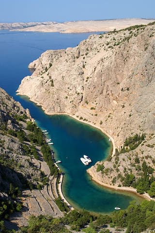
SVETI JURAJ
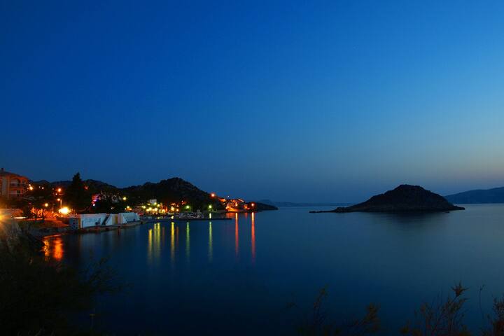
Sveti Juraj is a typical coastal destination located in a cove surrounded by the hill of Gradina on one side and the islet of Lisac on the other. In prehistory, a settlement called Lopsica was located here. The ruins of the Church of St. Philip and James (Sveti Filip i Jakov), which dates back to the Middle Ages, can be seen in the old cemetery by the sea. The beach is located right in the centre of the village. If you prefer more privacy, you can find it in the surrounding coves of Spasovac, Ujča, Vlaška, Planikovac, Kalić, Grabova and Rača.Apart from being a tourist resort, Sveti Juraj is known for the production of the finest flower honey in the world (OPG Rončević).
Sveti Juraj has 3 main gravel beaches, beach Banja (2 minutes walk from our apartments, it's under the house), beach Kotlina and beach Otinja. You can rent pedal boat or kayak on the beach.
There is a small children playground in the center of the village.
There are exursion boats from Sveti Juraj to islands nearby.
Taxi Daba operates with a 6 meter fast-boat and 10 meter slow-boat and take tourists to a nearby islands including Krk, Prvić, Goli Otok, Rab, Sv. Grgur. You can have a whole day trip, visiting more places, or they can just take you somewhere and come pick you up later.
It's usual to see the dolphins playing in the sea.
There are 5 restaurants and pizzeria in the village, and a beach bar.
Market 'Gavranović' in the centre of the village. If you are looking for supermarkets, the closest are in Senj (Plodine, Konzum).
You can buy fresh fish from the local fishermans.
In the center of the village is a small market with fresh fruit and vegetables.
In the village are 1 tobacco shop and ATM machine, near the main door of the market Gavranović).
In the evenings, almost everyday in summer, you can enjoy in beautiful sunsets and the view from Sveti Juraj.
12 Recomendado por los habitantes de la zona
Sveti Juraj
SVETI JURAJ
Sveti Juraj is a typical coastal destination located in a cove surrounded by the hill of Gradina on one side and the islet of Lisac on the other. In prehistory, a settlement called Lopsica was located here. The ruins of the Church of St. Philip and James (Sveti Filip i Jakov), which dates back to the Middle Ages, can be seen in the old cemetery by the sea. The beach is located right in the centre of the village. If you prefer more privacy, you can find it in the surrounding coves of Spasovac, Ujča, Vlaška, Planikovac, Kalić, Grabova and Rača.Apart from being a tourist resort, Sveti Juraj is known for the production of the finest flower honey in the world (OPG Rončević).
Sveti Juraj has 3 main gravel beaches, beach Banja (2 minutes walk from our apartments, it's under the house), beach Kotlina and beach Otinja. You can rent pedal boat or kayak on the beach.
There is a small children playground in the center of the village.
There are exursion boats from Sveti Juraj to islands nearby.
Taxi Daba operates with a 6 meter fast-boat and 10 meter slow-boat and take tourists to a nearby islands including Krk, Prvić, Goli Otok, Rab, Sv. Grgur. You can have a whole day trip, visiting more places, or they can just take you somewhere and come pick you up later.
It's usual to see the dolphins playing in the sea.
There are 5 restaurants and pizzeria in the village, and a beach bar.
Market 'Gavranović' in the centre of the village. If you are looking for supermarkets, the closest are in Senj (Plodine, Konzum).
You can buy fresh fish from the local fishermans.
In the center of the village is a small market with fresh fruit and vegetables.
In the village are 1 tobacco shop and ATM machine, near the main door of the market Gavranović).
In the evenings, almost everyday in summer, you can enjoy in beautiful sunsets and the view from Sveti Juraj.
Places to visit
The Northern Velebit National Park (Croatian: Nacionalni park Sjeverni Velebit) is a national park in Croatia that covers 109 km2 of the northern section of the Velebit mountains, the largest mountain range in Croatia. Because of the abundant variety of this part of the Velebit range, the area was upgraded from a nature reserve in 1999, and opened as a national park in September the same year.
Zavižan
Zavižan is one of the best-known localities in the Northern Velebit National Park. Located at 1594 m above sea level, underneath the Vučjak peak, is the mountain hut Zavižan and the oldest high-altitude weather station in Croatia, established in 1953. Since Velebit forms a natural border between continental and Mediterranean regions of Croatia, two different climates clash at its uppermost parts – the maritime and the continental climates - resulting in unpredictable weather conditions. This makes the Zavižan weather station invaluable to the meteorological community.
https://np-sjeverni-velebit.hr/www/en/
320 Recomendado por los habitantes de la zona
Parque Nacional de Velebit del Norte
96 no nameThe Northern Velebit National Park (Croatian: Nacionalni park Sjeverni Velebit) is a national park in Croatia that covers 109 km2 of the northern section of the Velebit mountains, the largest mountain range in Croatia. Because of the abundant variety of this part of the Velebit range, the area was upgraded from a nature reserve in 1999, and opened as a national park in September the same year.
Zavižan
Zavižan is one of the best-known localities in the Northern Velebit National Park. Located at 1594 m above sea level, underneath the Vučjak peak, is the mountain hut Zavižan and the oldest high-altitude weather station in Croatia, established in 1953. Since Velebit forms a natural border between continental and Mediterranean regions of Croatia, two different climates clash at its uppermost parts – the maritime and the continental climates - resulting in unpredictable weather conditions. This makes the Zavižan weather station invaluable to the meteorological community.
https://np-sjeverni-velebit.hr/www/en/
Starigrad-Donja Klada: walking trail along the sea with educational tables – about 1, 5 hour of walk
The first 3 km of the trail leading to Donja Klada are better preserved and arranged as an educational trail. The trail is about 1 m wide. Apart from benefiting from a walk in the fresh air and learning about natural and cultural values of this area, you can also enjoy pleasant views of the islands Rab and Goli otok located nearby.
In the first part of the trail from Starigrad, there is a section leading to an old fort. A favourable and protected location of this fort has enabled the population of this area since prehistoric times, through the medieval, up to the modern age, as we learn from numerous remains of material culture.
Along the whole trail there is a typical coastal vegetation (shrubland, coastal grassland and rocky ground).
How to reach the trail:
You can start the tour either in Starigrad or Donja Klada. Head south on the Adriatic Highway from Senj and turn right after 24, or 26 km, towards Donja Klada, or Starigrad.
The trail is for pedestrians only.
Starigrad kod Senja
Starigrad-Donja Klada: walking trail along the sea with educational tables – about 1, 5 hour of walk
The first 3 km of the trail leading to Donja Klada are better preserved and arranged as an educational trail. The trail is about 1 m wide. Apart from benefiting from a walk in the fresh air and learning about natural and cultural values of this area, you can also enjoy pleasant views of the islands Rab and Goli otok located nearby.
In the first part of the trail from Starigrad, there is a section leading to an old fort. A favourable and protected location of this fort has enabled the population of this area since prehistoric times, through the medieval, up to the modern age, as we learn from numerous remains of material culture.
Along the whole trail there is a typical coastal vegetation (shrubland, coastal grassland and rocky ground).
How to reach the trail:
You can start the tour either in Starigrad or Donja Klada. Head south on the Adriatic Highway from Senj and turn right after 24, or 26 km, towards Donja Klada, or Starigrad.
The trail is for pedestrians only.
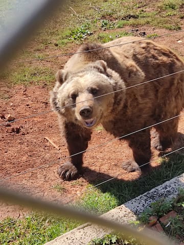
The Kuterevo Bear Refuge was founded in 2002 and ever since then bears are the main attraction in the village.
Right now, the refuge hosts 8 bears, 2 of which are coming from a Zoo and the rest lost their mothers during their first year of life and thus had no chance of survival in the wild.
The Refuge is separated in two parts – the first one is dedicated for the younger bears and the second for the older ones. In this moment we have three bears in the first part – Marko Kralj, born in 2012; and Mlada Gora and Mlad Dol, both born in 2010. And in the second part we have five bears in total: VladMir, born in 2008; BlagoZoo, born in 2007, coming from the Zoo in Zagreb; LjuboLik and ZdraviGor, both born in 2003. All of these males share one enclosure, and the Lady of the Refuge – Mirna, lives in another enclosure all by herself. She spent almost all her live in the Zoo in Split, but joined Kuterevo in April 2015. Being born in 1984, she is now almost blind and deaf and she is the oldest bear in the Refuge.
72 Recomendado por los habitantes de la zona
Kuterevo
The Kuterevo Bear Refuge was founded in 2002 and ever since then bears are the main attraction in the village.
Right now, the refuge hosts 8 bears, 2 of which are coming from a Zoo and the rest lost their mothers during their first year of life and thus had no chance of survival in the wild.
The Refuge is separated in two parts – the first one is dedicated for the younger bears and the second for the older ones. In this moment we have three bears in the first part – Marko Kralj, born in 2012; and Mlada Gora and Mlad Dol, both born in 2010. And in the second part we have five bears in total: VladMir, born in 2008; BlagoZoo, born in 2007, coming from the Zoo in Zagreb; LjuboLik and ZdraviGor, both born in 2003. All of these males share one enclosure, and the Lady of the Refuge – Mirna, lives in another enclosure all by herself. She spent almost all her live in the Zoo in Split, but joined Kuterevo in April 2015. Being born in 1984, she is now almost blind and deaf and she is the oldest bear in the Refuge.
Zavratnica Bay - the most exquisite pearls on the Croatian coast
Zavratnica is a 900 m long narrow inlet located at the foot of the mighty Velebit Mountains, in the northern part of the Adriatic Sea, 1 km south of Jablanac. The bay is about 50-150 m wide. Because of its natural values even in 1964 was declared a protected landscape, and since 1981 is an integral part of the Nature Park Velebit. At the begining of 20th century a promenade and terrace in the center of the bay were built to prevent further deterioration. To stop the torrents coming from the mountain in the the cascades and terraces cypresses, alpine pine, fig, holm oak and other trees were planted. Zavratnica is the habitat of 129 plant species, of which 100 indigenous.
How to reach Zavratnica: You can reach Zavratnica from Jablanac, a ferry port for the island of Rab, in a 30 minutes walk down a path along the sea. If you prefer hiking or are seeking adventure, take a trail from the village of Zavratnica.
105 Recomendado por los habitantes de la zona
Zavratnica
Zavratnica Bay - the most exquisite pearls on the Croatian coast
Zavratnica is a 900 m long narrow inlet located at the foot of the mighty Velebit Mountains, in the northern part of the Adriatic Sea, 1 km south of Jablanac. The bay is about 50-150 m wide. Because of its natural values even in 1964 was declared a protected landscape, and since 1981 is an integral part of the Nature Park Velebit. At the begining of 20th century a promenade and terrace in the center of the bay were built to prevent further deterioration. To stop the torrents coming from the mountain in the the cascades and terraces cypresses, alpine pine, fig, holm oak and other trees were planted. Zavratnica is the habitat of 129 plant species, of which 100 indigenous.
How to reach Zavratnica: You can reach Zavratnica from Jablanac, a ferry port for the island of Rab, in a 30 minutes walk down a path along the sea. If you prefer hiking or are seeking adventure, take a trail from the village of Zavratnica.
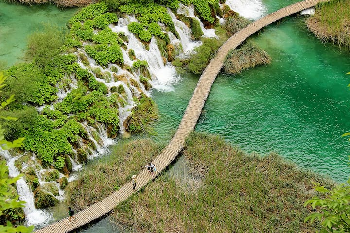
Plitvice Lakes is the oldest and largest national park in the Republic of Croatia. The park is situated in the mountainous region of Croatia, between the Mala Kapela mountain range in the west and northwest, and the Lička Plješivica mountain range to the southeast. Administratively, the park falls within two counties: Lika-Senj (90.7%) and Karlovac (9.3%).
With its exceptional natural beauty, this area has always attracted nature lovers, and already on 8 April 1949, it was proclaimed Croatia’s first national park. The process of tufa formation, which results in the building of the tufa, or travertine, barriers and resulted in the creation of the lakes, is the outstanding universal value, for which the Plitvice Lakes were internationally recognised on 26 October 1979 with their inscription onto the UNESCO World Heritage List. In 1997, the boundaries of the national park were expanded, and today it covers an area just under 300 km2.
The park is primarily covered in forest vegetation, with smaller areas under grasslands. The most attractive part of the park – the lakes – cover just under 1% of the total park area.
The lake system is comprised of 16 named and several smaller unnamed lakes, cascading one into the next. Due to the geological substrate and characteristic hydrogeological conditions, the lake system has been divided into the Upper and Lower lakes. The twelve lakes forming the Upper Lakes are: Prošćansko jezero, Ciginovac, Okrugljak, Batinovac, Veliko jezero, Malo jezero, Vir, Galovac, Milino jezero, Gradinsko jezero, Burgeti and Kozjak. These lakes were formed on impermeable dolomite rock, and are larger, with more indented and gentler shores than the Lower Lakes. The Lower Lakes, consisting of the lakes Milanovac, Gavanovac, Kaluđerovac and Novakovića Brod, were formed in permeable limestone substrate, cut into a deep canyon with steep cliffs. The lakes end in the impressive waterfalls Sastavci, with the Korana River springing under the base of the falls.
The Plitvice Lakes National Park offers visitors seven different routes to tour the lake system, and four hiking trails. The park is open to visitors year round. All visitors are required to follow the instructions listed on the information panels, to keep on the marked trails, and to leave no traces of their visit, such as litter, or marking or devastating nature in any form.
The following is strictly prohibited in the National Park:
Collection of plant materials, or taking any “souvenirs” of natural origin
Feeding the animals
Swimming in the lakes
Disposal of litter along the trails or elsewhere, except in the garbage bins installed throughout the park
Straying off the marked trails
Some recommendation tips:
Wearing the appropriate clothing and footwear
Bringing adequate rain and sun protection (umbrella, raincoat; sunglasses, hat, sunscreen – depending on the season)
Check the weather forecast before coming to the park
Be sure to check the information listed on their website about the length of certain trails, to ensure to you have enough time to complete the desired tour.
Website:
https://np-plitvicka-jezera.hr/
1554 Recomendado por los habitantes de la zona
Parque Nacional de los Lagos de Plitvice
Plitvice Lakes is the oldest and largest national park in the Republic of Croatia. The park is situated in the mountainous region of Croatia, between the Mala Kapela mountain range in the west and northwest, and the Lička Plješivica mountain range to the southeast. Administratively, the park falls within two counties: Lika-Senj (90.7%) and Karlovac (9.3%).
With its exceptional natural beauty, this area has always attracted nature lovers, and already on 8 April 1949, it was proclaimed Croatia’s first national park. The process of tufa formation, which results in the building of the tufa, or travertine, barriers and resulted in the creation of the lakes, is the outstanding universal value, for which the Plitvice Lakes were internationally recognised on 26 October 1979 with their inscription onto the UNESCO World Heritage List. In 1997, the boundaries of the national park were expanded, and today it covers an area just under 300 km2.
The park is primarily covered in forest vegetation, with smaller areas under grasslands. The most attractive part of the park – the lakes – cover just under 1% of the total park area.
The lake system is comprised of 16 named and several smaller unnamed lakes, cascading one into the next. Due to the geological substrate and characteristic hydrogeological conditions, the lake system has been divided into the Upper and Lower lakes. The twelve lakes forming the Upper Lakes are: Prošćansko jezero, Ciginovac, Okrugljak, Batinovac, Veliko jezero, Malo jezero, Vir, Galovac, Milino jezero, Gradinsko jezero, Burgeti and Kozjak. These lakes were formed on impermeable dolomite rock, and are larger, with more indented and gentler shores than the Lower Lakes. The Lower Lakes, consisting of the lakes Milanovac, Gavanovac, Kaluđerovac and Novakovića Brod, were formed in permeable limestone substrate, cut into a deep canyon with steep cliffs. The lakes end in the impressive waterfalls Sastavci, with the Korana River springing under the base of the falls.
The Plitvice Lakes National Park offers visitors seven different routes to tour the lake system, and four hiking trails. The park is open to visitors year round. All visitors are required to follow the instructions listed on the information panels, to keep on the marked trails, and to leave no traces of their visit, such as litter, or marking or devastating nature in any form.
The following is strictly prohibited in the National Park:
Collection of plant materials, or taking any “souvenirs” of natural origin
Feeding the animals
Swimming in the lakes
Disposal of litter along the trails or elsewhere, except in the garbage bins installed throughout the park
Straying off the marked trails
Some recommendation tips:
Wearing the appropriate clothing and footwear
Bringing adequate rain and sun protection (umbrella, raincoat; sunglasses, hat, sunscreen – depending on the season)
Check the weather forecast before coming to the park
Be sure to check the information listed on their website about the length of certain trails, to ensure to you have enough time to complete the desired tour.
Website:
https://np-plitvicka-jezera.hr/
The Gacka Valley is a large karst valley fringed with mountain ranges of Velebit on the coast side and with Kapela Mountain on the inland side. The valley is dominated by the river Gacka which springs at one end of the valley and sinks underground on the opposite end. Gacka is the third longest sinking river in the world. Originally 32 km long, the river’s course was cut down to 11 km with the construction of the Hydro Electric Power Plant Senj in 1960. In the Otočac area, most of the river’s waters are diverted through tunnels to an artificial lake called the Gusić Jezero. Owing to a gently sloping terrain, the river’s course is tranquil and winding. The waters of Gacka are extremely clean and rich in oxygen.
The largest town in the Gacka area is Otočac, originally built at a river fork where the Gacka branches formed an “island” surrounded by water on all sides. Today Otočac has 4,000 inhabitants.
The Gacka source area consists of numerous smaller springs, the three strongest among them: the Tonković Vrilo, Klanac and Majerovo Vrilo. The springs resembling little lakes are very picturesque. To be seen here are many old watermills – malenice, many of which reconstructed and restored in a traditional style. There are also saw mills, fulling mills and cloth washing troughs. The people inhabiting the Gacka area navigated the river using plav, traditional boats carved from fir tree trunks, typical for the Gacka. The river is rich in diverse water plants which are so abundant that people harvest them as cattle feed. Until 1937, only four fish species inhabited the Gacka: trout, European eel, weather loach, and pike, probably introduced during the reign of the Frankopan dukes. Gacka also provided habitat to stone crayfish which disappeared in 1931 due to crab plague. Later, numerous other fish species were introduced into the Gacka, while other made their way to the river through the canal built between Gacka and the Lika rivers to serve the Hydro Electric Power Plant. To be found in the Gacka today are also the rainbow trout, grayling, carp, tench, roach, chub, and pumpkinseed. These introduced species have disturbed the biological balance and reduced the purity of water. Trout in the Gacka grow very fast (about five times faster than in other karst rivers) and are known among anglers throughout the globe.
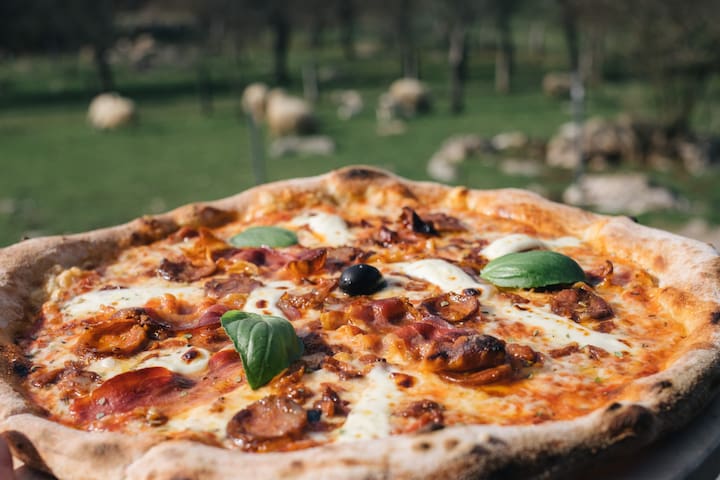
TIP:
Check the best pizza in Lika: PIZZERIA RUSPANTE in Majerovo Vrilo, Sinac 135, 53224, Otočac.
You have to make a table reservation: 053787787
https://www.tripadvisor.com/Restaurant_Review-g1203157-d15043063-Reviews-Pizzeria_Ruspante-Otocac_Lika_Senj_County.html
https://www.google.com/maps/place/Pizzeria+Ruspante/@44.8145823,15.3547444,562m/data=!3m1!1e3!4m5!3m4!1s0x4763dde9072de7f7:0x887858620f8e98c3!8m2!3d44.8145823!4d15.3569331
12 Recomendado por los habitantes de la zona
Gacka springs
The Gacka Valley is a large karst valley fringed with mountain ranges of Velebit on the coast side and with Kapela Mountain on the inland side. The valley is dominated by the river Gacka which springs at one end of the valley and sinks underground on the opposite end. Gacka is the third longest sinking river in the world. Originally 32 km long, the river’s course was cut down to 11 km with the construction of the Hydro Electric Power Plant Senj in 1960. In the Otočac area, most of the river’s waters are diverted through tunnels to an artificial lake called the Gusić Jezero. Owing to a gently sloping terrain, the river’s course is tranquil and winding. The waters of Gacka are extremely clean and rich in oxygen.
The largest town in the Gacka area is Otočac, originally built at a river fork where the Gacka branches formed an “island” surrounded by water on all sides. Today Otočac has 4,000 inhabitants.
The Gacka source area consists of numerous smaller springs, the three strongest among them: the Tonković Vrilo, Klanac and Majerovo Vrilo. The springs resembling little lakes are very picturesque. To be seen here are many old watermills – malenice, many of which reconstructed and restored in a traditional style. There are also saw mills, fulling mills and cloth washing troughs. The people inhabiting the Gacka area navigated the river using plav, traditional boats carved from fir tree trunks, typical for the Gacka. The river is rich in diverse water plants which are so abundant that people harvest them as cattle feed. Until 1937, only four fish species inhabited the Gacka: trout, European eel, weather loach, and pike, probably introduced during the reign of the Frankopan dukes. Gacka also provided habitat to stone crayfish which disappeared in 1931 due to crab plague. Later, numerous other fish species were introduced into the Gacka, while other made their way to the river through the canal built between Gacka and the Lika rivers to serve the Hydro Electric Power Plant. To be found in the Gacka today are also the rainbow trout, grayling, carp, tench, roach, chub, and pumpkinseed. These introduced species have disturbed the biological balance and reduced the purity of water. Trout in the Gacka grow very fast (about five times faster than in other karst rivers) and are known among anglers throughout the globe.
TIP:
Check the best pizza in Lika: PIZZERIA RUSPANTE in Majerovo Vrilo, Sinac 135, 53224, Otočac.
You have to make a table reservation: 053787787
https://www.tripadvisor.com/Restaurant_Review-g1203157-d15043063-Reviews-Pizzeria_Ruspante-Otocac_Lika_Senj_County.html
https://www.google.com/maps/place/Pizzeria+Ruspante/@44.8145823,15.3547444,562m/data=!3m1!1e3!4m5!3m4!1s0x4763dde9072de7f7:0x887858620f8e98c3!8m2!3d44.8145823!4d15.3569331
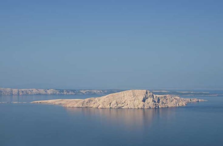
Goli Otok is a barren, uninhabited island that was the site of a political prison which was in use when Croatia was part of Yugoslavia.
The prison was in operation between 1949 and 1989.
Among Goli Otok’s inmates, there were people who had been World War II heroes or had been prisoners in Nazi and fascist concentration camps during World War II.
In the camp, over 300 inmates lost their lives during the seven years it was open, dying from various causes – executions, killings by other inmates, the consequences of hard labour, typhus and other diseases.
In the summer season there are regular tourist boats going there. Go off season, though, and you may have the entire island and its ghost towns to yourself.
You can choose excursion or taxi boats from Sveti Juraj or Senj.
79 Recomendado por los habitantes de la zona
Goli otok
Goli Otok is a barren, uninhabited island that was the site of a political prison which was in use when Croatia was part of Yugoslavia.
The prison was in operation between 1949 and 1989.
Among Goli Otok’s inmates, there were people who had been World War II heroes or had been prisoners in Nazi and fascist concentration camps during World War II.
In the camp, over 300 inmates lost their lives during the seven years it was open, dying from various causes – executions, killings by other inmates, the consequences of hard labour, typhus and other diseases.
In the summer season there are regular tourist boats going there. Go off season, though, and you may have the entire island and its ghost towns to yourself.
You can choose excursion or taxi boats from Sveti Juraj or Senj.