
Place to visit
Place to visit
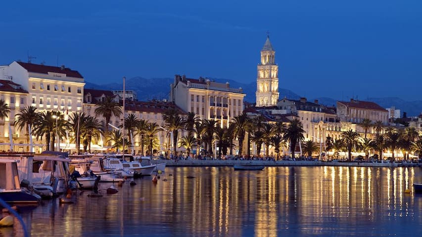
Split is the second-largest city of Croatia and the largest city of the region of Dalmatia, with about 250,000 people living in its urban area. It lies on the eastern shore of the Adriatic Sea and is spread over a central peninsula and its surroundings. An intraregional transport hub and popular tourist destination, the city is linked to the Adriatic islands and the Apennine peninsula.
In 1979, the historic center of Split was included into the UNESCO list of World Heritage Sites. Split is said to be one of the centres of Croatian culture.
875 Recomendado por los habitantes de la zona
Split
Split is the second-largest city of Croatia and the largest city of the region of Dalmatia, with about 250,000 people living in its urban area. It lies on the eastern shore of the Adriatic Sea and is spread over a central peninsula and its surroundings. An intraregional transport hub and popular tourist destination, the city is linked to the Adriatic islands and the Apennine peninsula.
In 1979, the historic center of Split was included into the UNESCO list of World Heritage Sites. Split is said to be one of the centres of Croatian culture.
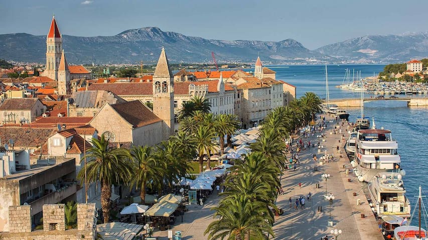
Trogir is a historic town and harbour on the Adriatic coast in Split-Dalmatia County, Croatia, with a population of 10,818 (2011) and a total municipal population of 13,260 (2011). The historic city of Trogir is situated on a small island between the Croatian mainland and the island of Čiovo. It lies 27 kilometres (17 miles) west of the city of Split.
Since 1997, the historic centre of Trogir has been included in the UNESCO list of World Heritage Sites[4] for its Venetian architecture.
The most important sites include:
Historical city core, with about 10 churches and numerous buildings from the 13th century
The city gate (17th century) and city walls (15th century)
The Fortress Kamerlengo (15th century)
The Duke's Palace (13th century)
The Cathedral (13th century) with the Portal of Master Radovan, the unique work of this Dalmatian artist
The big and small palaces Cipiko from the 15th century
The city loggia from 15th century.
1248 Recomendado por los habitantes de la zona
Trogir
Trogir is a historic town and harbour on the Adriatic coast in Split-Dalmatia County, Croatia, with a population of 10,818 (2011) and a total municipal population of 13,260 (2011). The historic city of Trogir is situated on a small island between the Croatian mainland and the island of Čiovo. It lies 27 kilometres (17 miles) west of the city of Split.
Since 1997, the historic centre of Trogir has been included in the UNESCO list of World Heritage Sites[4] for its Venetian architecture.
The most important sites include:
Historical city core, with about 10 churches and numerous buildings from the 13th century
The city gate (17th century) and city walls (15th century)
The Fortress Kamerlengo (15th century)
The Duke's Palace (13th century)
The Cathedral (13th century) with the Portal of Master Radovan, the unique work of this Dalmatian artist
The big and small palaces Cipiko from the 15th century
The city loggia from 15th century.
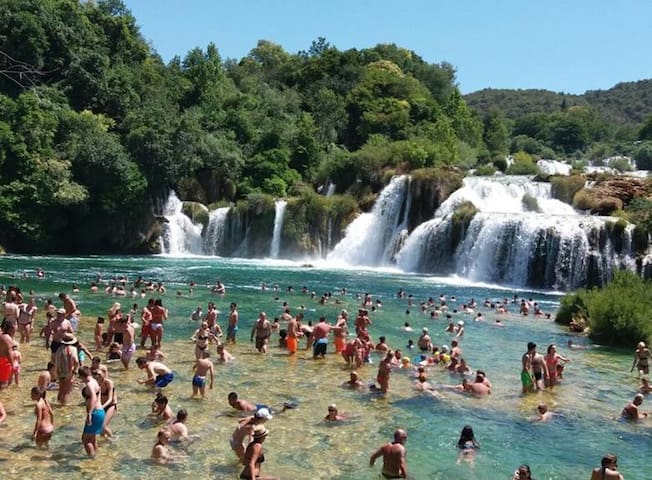
Krka National Park (Croatian: Nacionalni park Krka) is one of the Croatian national parks, named after the river Krka (ancient Greek: Kyrikos) that it encloses. It is located along the middle-lower course of the Krka River in central Dalmatia, in Šibenik-Knin county, downstream Miljevci area, and just a few kilometers northeast of the city of Šibenik. It was formed to protect the Krka River and is intended primarily for scientific, cultural, educational, recreational, and tourism activities. It is the seventh national park in Croatia and was proclaimed a national park in 1985.
2699 Recomendado por los habitantes de la zona
Parque Nacional Krka
Krka National Park (Croatian: Nacionalni park Krka) is one of the Croatian national parks, named after the river Krka (ancient Greek: Kyrikos) that it encloses. It is located along the middle-lower course of the Krka River in central Dalmatia, in Šibenik-Knin county, downstream Miljevci area, and just a few kilometers northeast of the city of Šibenik. It was formed to protect the Krka River and is intended primarily for scientific, cultural, educational, recreational, and tourism activities. It is the seventh national park in Croatia and was proclaimed a national park in 1985.
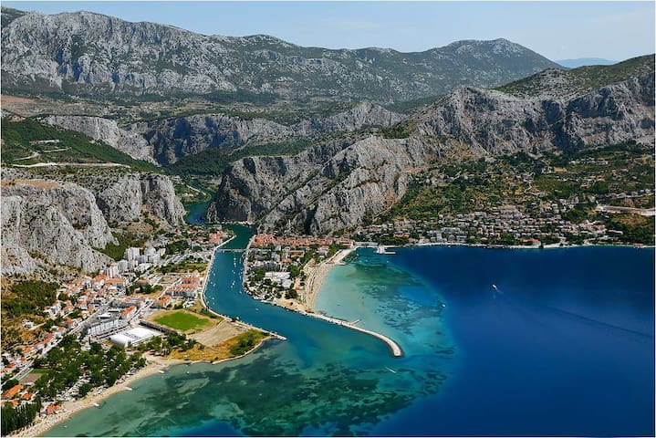
Omiš is a town and port in the Dalmatia region of Croatia, and is a municipality in the Split-Dalmatia County. The town is situated approximately 25 kilometres (16 miles) south-east of Croatia's second largest city, Split. Its location is where the Cetina River meets the Adriatic Sea. Omiš municipality has a population of 14,936 and its area is 266 square kilometres (103 sq mi).
Omiš was well known in the past by the Corsairs of Almissa (Omiški gusari) whose Sagittas (ships), brought fame to them because they were built for attack and fast retrieval into the mouth of the Cetina River, protecting the town from foreign invaders. At a very early date, neighbours of the Corsairs of Almissa, the highlanders of the Poljica Principality [5] (Poljička Republika), became their friends and allies. This allowed them to harass the seaborne trade, without fear of a sudden attack from inland.
499 Recomendado por los habitantes de la zona
Omiš
Omiš is a town and port in the Dalmatia region of Croatia, and is a municipality in the Split-Dalmatia County. The town is situated approximately 25 kilometres (16 miles) south-east of Croatia's second largest city, Split. Its location is where the Cetina River meets the Adriatic Sea. Omiš municipality has a population of 14,936 and its area is 266 square kilometres (103 sq mi).
Omiš was well known in the past by the Corsairs of Almissa (Omiški gusari) whose Sagittas (ships), brought fame to them because they were built for attack and fast retrieval into the mouth of the Cetina River, protecting the town from foreign invaders. At a very early date, neighbours of the Corsairs of Almissa, the highlanders of the Poljica Principality [5] (Poljička Republika), became their friends and allies. This allowed them to harass the seaborne trade, without fear of a sudden attack from inland.
Primošten is famous for its huge and beautiful vineyards. A photo of the vineyards of Primošten hung in the UN center in New York. Apart from its vineyards, Primošten is also known for the traditional donkey race that takes place there every summer. The largest beach in Primošten is called Raduča, and its smaller part, Mala Raduča, is voted one of the 10 most beautiful beaches in Croatia. The area's vineyards are currently under consideration to become a UNESCO World Heritage site.[2]
238 Recomendado por los habitantes de la zona
Primošten
Primošten is famous for its huge and beautiful vineyards. A photo of the vineyards of Primošten hung in the UN center in New York. Apart from its vineyards, Primošten is also known for the traditional donkey race that takes place there every summer. The largest beach in Primošten is called Raduča, and its smaller part, Mala Raduča, is voted one of the 10 most beautiful beaches in Croatia. The area's vineyards are currently under consideration to become a UNESCO World Heritage site.[2]
Krknjasi bay on the east coast of the island Veli Drvenik is known as the Blue Lagoon for its incredible hue of crystal clear water which create an unique tropical paradise.
9 Recomendado por los habitantes de la zona
Otok Krknjaš Veli
Krknjasi bay on the east coast of the island Veli Drvenik is known as the Blue Lagoon for its incredible hue of crystal clear water which create an unique tropical paradise.
The Zlatni Rat, often referred to as the Golden Cape or Golden Horn (translated from the local Chakavian dialect), is a spit of land located about 2 kilometres (1 mile) west from the harbour town of Bol on the southern coast of the Croatian island of Brač, in the region of Dalmatia.The beaches on either side of the spit extend for some 634 metres (2,080 ft) altogether, but the exact shape and length of the landform varies with regard to changes in tide, current, and wind. The spit points directly south. The farthest end, which is usually turned slightly towards the east, will often shift to the west in certain weather conditions, esp. a strong south-easterly wind known in Croatia as the Jugo. Changes in the shape of the beach occur once in every two to three years, and have been observed in 2010, 2016 and 2018.
324 Recomendado por los habitantes de la zona
Cuerno de Oro
Put Zlatnog RataThe Zlatni Rat, often referred to as the Golden Cape or Golden Horn (translated from the local Chakavian dialect), is a spit of land located about 2 kilometres (1 mile) west from the harbour town of Bol on the southern coast of the Croatian island of Brač, in the region of Dalmatia.The beaches on either side of the spit extend for some 634 metres (2,080 ft) altogether, but the exact shape and length of the landform varies with regard to changes in tide, current, and wind. The spit points directly south. The farthest end, which is usually turned slightly towards the east, will often shift to the west in certain weather conditions, esp. a strong south-easterly wind known in Croatia as the Jugo. Changes in the shape of the beach occur once in every two to three years, and have been observed in 2010, 2016 and 2018.
The island of Hvar is unusual in the area for having a large fertile coastal plain, and fresh water springs. Its hillsides are covered in pine forests, with vineyards, olive groves, fruit orchards and lavender fields in the agricultural areas. The climate is characterized by mild winters, and warm summers with many hours of sunshine. The island has 11,103 residents, making it the 4th most populated of the Croatian islands.
Hvar's location at the center of the Adriatic sailing routes has long made this island an important base for commanding trade up and down the Adriatic, across to Italy and throughout the wider Mediterranean. It has been inhabited since pre-historic times, originally by a Neolithic people whose distinctive pottery gave rise to the term Hvar culture, and later by the Illyrians. The ancient Greeks founded the colony of Pharos in 384 BC on the site of today's Stari Grad, making it one of the oldest towns in Europe. They were also responsible for setting out the agricultural field divisions of the Stari Grad Plain, now a UNESCO World Heritage Site. In medieval times, the City of Hvar rose to importance within the Venetian Empire as a major naval base. Prosperity brought culture and the arts, with one of the first public theatres in Europe, nobles’ palaces and many fine communal buildings.
One industry, tourism, has however continued to grow and is now a significant contributor to the island's economy. The formation of The Hygienic Association of Hvar in 1868 for the assistance of visitors to the island has been instrumental in developing an infrastructure of hotels, apartments, restaurants, marinas, museums, galleries and cafés. Today, the island of Hvar is a popular destination, consistently listed in the top 10 islands by Conde Nast Traveler magazine.
276 Recomendado por los habitantes de la zona
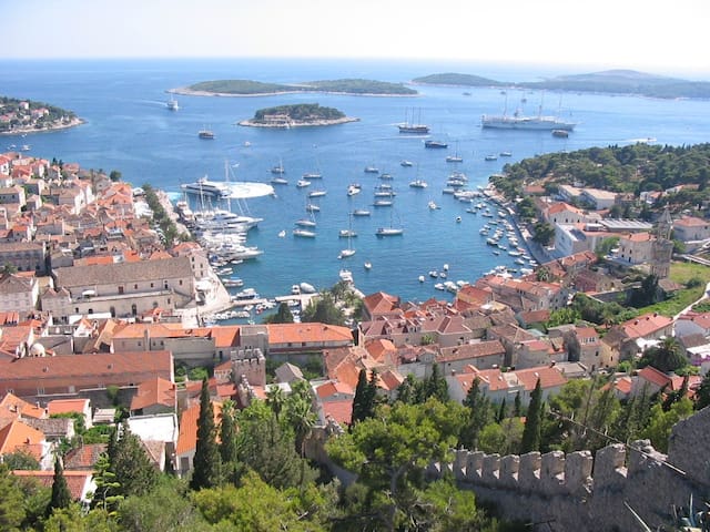
Hvar
The island of Hvar is unusual in the area for having a large fertile coastal plain, and fresh water springs. Its hillsides are covered in pine forests, with vineyards, olive groves, fruit orchards and lavender fields in the agricultural areas. The climate is characterized by mild winters, and warm summers with many hours of sunshine. The island has 11,103 residents, making it the 4th most populated of the Croatian islands.
Hvar's location at the center of the Adriatic sailing routes has long made this island an important base for commanding trade up and down the Adriatic, across to Italy and throughout the wider Mediterranean. It has been inhabited since pre-historic times, originally by a Neolithic people whose distinctive pottery gave rise to the term Hvar culture, and later by the Illyrians. The ancient Greeks founded the colony of Pharos in 384 BC on the site of today's Stari Grad, making it one of the oldest towns in Europe. They were also responsible for setting out the agricultural field divisions of the Stari Grad Plain, now a UNESCO World Heritage Site. In medieval times, the City of Hvar rose to importance within the Venetian Empire as a major naval base. Prosperity brought culture and the arts, with one of the first public theatres in Europe, nobles’ palaces and many fine communal buildings.
One industry, tourism, has however continued to grow and is now a significant contributor to the island's economy. The formation of The Hygienic Association of Hvar in 1868 for the assistance of visitors to the island has been instrumental in developing an infrastructure of hotels, apartments, restaurants, marinas, museums, galleries and cafés. Today, the island of Hvar is a popular destination, consistently listed in the top 10 islands by Conde Nast Traveler magazine.
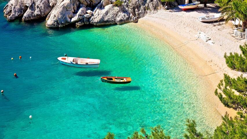
Brela is a tourist town located between the Biokovo mountain and the Adriatic Sea. It is known as the pearl of Makarska riviera. The pearl of Adriatic or the pearl of Mediterranean is the name given to the city of Dubrovnik. In 1968 Brela was crowned as "Champion of Adriatic" for high achievements in tourist activity.
The symbol of Brela is "Kamen Brela" (Brela Stone), a small rock island just off the main beach in Brela, the Punta Rata beach. In 2004, American magazine Forbes put the Punta Rata beach on the list of 10 world's most beautiful beaches, where it is ranked 6th in the world and 1st in Europe.
62 Recomendado por los habitantes de la zona
Brela
Brela is a tourist town located between the Biokovo mountain and the Adriatic Sea. It is known as the pearl of Makarska riviera. The pearl of Adriatic or the pearl of Mediterranean is the name given to the city of Dubrovnik. In 1968 Brela was crowned as "Champion of Adriatic" for high achievements in tourist activity.
The symbol of Brela is "Kamen Brela" (Brela Stone), a small rock island just off the main beach in Brela, the Punta Rata beach. In 2004, American magazine Forbes put the Punta Rata beach on the list of 10 world's most beautiful beaches, where it is ranked 6th in the world and 1st in Europe.
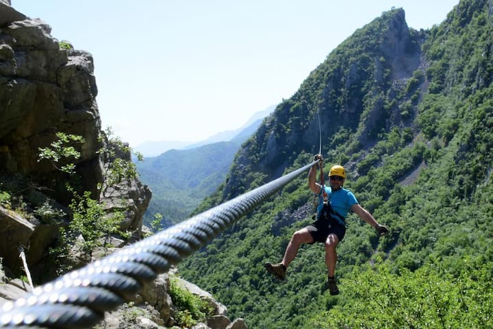
The adrenalin infused ZIPLINE polygon is located in the canyon of the River Cetina, 3 km from Omiš. It consists of eight (8) steel cables across which participants, sitting in a belt, descend down the canyon.
The total length of the cables is 2,100 m, the longest of which is 700 m and is 150 m above ground level. To cross the entire polygon accompanied by two guides, a group of 10 persons requires two and a half hours.
Transport to the starting point and back is organised with our vehicles. Before the start, there is a training session during which time each participant receives their equipment. There are 2 short cables, 25 m long, on which the guides demonstrate how to behave on the ZIPLINE. This is followed by a short stroll to the first cable through stunning scenery. At each cable, one of the guides demonstrates the descent while the second guide attaches the participants onto the cable and provides instructions.
The finishing point is 50m from the road where a vehicle waits to take participants back to the ZIPLINE agency in Omis.
ZIPLINE tours take place all day throughout the summer season and by appointment during the remainder of the year.
ZIPLINE offers you 3 unforgettable hours (depending on the size of the group) of fun and stunning nature.
https://zipline-croatia.com/en/
144 Recomendado por los habitantes de la zona
Zipline
4 Ul. Josipa PupačićaThe adrenalin infused ZIPLINE polygon is located in the canyon of the River Cetina, 3 km from Omiš. It consists of eight (8) steel cables across which participants, sitting in a belt, descend down the canyon.
The total length of the cables is 2,100 m, the longest of which is 700 m and is 150 m above ground level. To cross the entire polygon accompanied by two guides, a group of 10 persons requires two and a half hours.
Transport to the starting point and back is organised with our vehicles. Before the start, there is a training session during which time each participant receives their equipment. There are 2 short cables, 25 m long, on which the guides demonstrate how to behave on the ZIPLINE. This is followed by a short stroll to the first cable through stunning scenery. At each cable, one of the guides demonstrates the descent while the second guide attaches the participants onto the cable and provides instructions.
The finishing point is 50m from the road where a vehicle waits to take participants back to the ZIPLINE agency in Omis.
ZIPLINE tours take place all day throughout the summer season and by appointment during the remainder of the year.
ZIPLINE offers you 3 unforgettable hours (depending on the size of the group) of fun and stunning nature.
https://zipline-croatia.com/en/
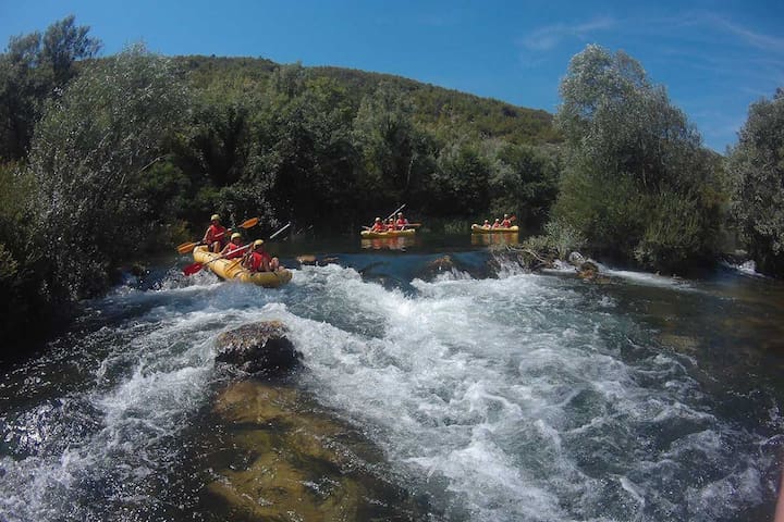
For all those who like to enjoy beauty of the nature while being adventurous, there's no better choice than going on a rafting trip down Cetina river. Rafting on Cetina river is an unforgettable experience you just can not miss.
Rafting adventure starts with the ride from Split to the Cetina river canyon where you will get your complete rafting gear, rafting boat and professional skippers ready to make your rafting experience smooth and unforgettable.
Rafting tour lasts for three hours taking you down the 10 km long rafting route all while enjoying beautiful nature, crystal clear waters and abundance of wildlife. Alternating rapids and waterfalls make the route even more exciting and interesting. You do not want to miss this adrenaline filled adventure.
25 Recomendado por los habitantes de la zona
Adventure Omis | Canyoning Kayaking Rafting Biking Climbing
32 Cetinska cestaFor all those who like to enjoy beauty of the nature while being adventurous, there's no better choice than going on a rafting trip down Cetina river. Rafting on Cetina river is an unforgettable experience you just can not miss.
Rafting adventure starts with the ride from Split to the Cetina river canyon where you will get your complete rafting gear, rafting boat and professional skippers ready to make your rafting experience smooth and unforgettable.
Rafting tour lasts for three hours taking you down the 10 km long rafting route all while enjoying beautiful nature, crystal clear waters and abundance of wildlife. Alternating rapids and waterfalls make the route even more exciting and interesting. You do not want to miss this adrenaline filled adventure.
Blue Cave or Blue Grotto as some call it. It is a small sea cave on the island of Biševo, just five kilometers southwest from island of Vis. What makes this cave so special is its beautiful blue glow which comes from wide opening below sea level. Actually, Blue cave has two openings. Smaller one through which boat can pass and wider one below sea level through which sunlight penetrates and makes cave glow in magnificent blue. This mesmerizing blue light will make you try and swim or dive in the cave but unfortunately it is forbidden. However, it is still worth your time.
48 Recomendado por los habitantes de la zona
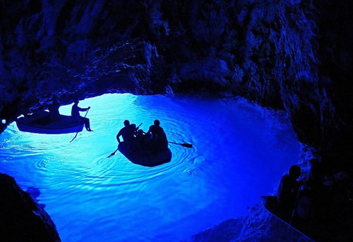
Blue Grotto
Blue Cave or Blue Grotto as some call it. It is a small sea cave on the island of Biševo, just five kilometers southwest from island of Vis. What makes this cave so special is its beautiful blue glow which comes from wide opening below sea level. Actually, Blue cave has two openings. Smaller one through which boat can pass and wider one below sea level through which sunlight penetrates and makes cave glow in magnificent blue. This mesmerizing blue light will make you try and swim or dive in the cave but unfortunately it is forbidden. However, it is still worth your time.
With its exceptional natural beauty, this area has always attracted nature lovers, and already on 8 April 1949, it was proclaimed Croatia’s first national park. The process of tufa formation, which results in the building of the tufa, or travertine, barriers and resulted in the creation of the lakes, is the outstanding universal value, for which the Plitvice Lakes were internationally recognised on 26 October 1979 with their inscription onto the UNESCO World Heritage List.
1554 Recomendado por los habitantes de la zona
Parque Nacional de los Lagos de Plitvice
With its exceptional natural beauty, this area has always attracted nature lovers, and already on 8 April 1949, it was proclaimed Croatia’s first national park. The process of tufa formation, which results in the building of the tufa, or travertine, barriers and resulted in the creation of the lakes, is the outstanding universal value, for which the Plitvice Lakes were internationally recognised on 26 October 1979 with their inscription onto the UNESCO World Heritage List.
Ninska Laguna Beach is located in a small historical town of Nin. Laguna is one of the best known and most popular beaches in this area and the favorite beach of tourists and locals.
Laguna is a beautiful sandy beach with a view that goes back to the mountains which attracts many people. Ninska Laguna is also known as the "Queen's beach" and is ideal for families with children because of its shallow waters and warm temperatures.
The beach contains outdoor showers, public toilets, changing rooms and there is a possibility of renting deck- chairs and beach umbrellas. Some believe that the beach is ideal for camping because it is located away from large crowds and traffic.
The beach is a rich with healing mud that helps cure various diseases. Sports enthusiasts can enjoy volleyball, kite, badminton and many other activities on the Ninska Laguna beach. If you want to freshen up during the summer heat there are numerous bars, restaurants and other establishments on the beach where you can enjoy a large offer of Dalmatian specialties.
15 Recomendado por los habitantes de la zona
Ninska Laguna Beach
Ninska Laguna Beach is located in a small historical town of Nin. Laguna is one of the best known and most popular beaches in this area and the favorite beach of tourists and locals.
Laguna is a beautiful sandy beach with a view that goes back to the mountains which attracts many people. Ninska Laguna is also known as the "Queen's beach" and is ideal for families with children because of its shallow waters and warm temperatures.
The beach contains outdoor showers, public toilets, changing rooms and there is a possibility of renting deck- chairs and beach umbrellas. Some believe that the beach is ideal for camping because it is located away from large crowds and traffic.
The beach is a rich with healing mud that helps cure various diseases. Sports enthusiasts can enjoy volleyball, kite, badminton and many other activities on the Ninska Laguna beach. If you want to freshen up during the summer heat there are numerous bars, restaurants and other establishments on the beach where you can enjoy a large offer of Dalmatian specialties.